Helping families find their way at Camelback Cemetery
A map at the gate and restored lot markers for one of the oldest cemeteries in the Valley, so every visitor can walk straight to the person they came to see.
I'm a Life Scout with Troop 6 in Phoenix, working toward the rank of Eagle Scout. For my Eagle service project I'm partnering with the Camelback Cemetery Association to make their historic cemetery easier to visit.
Today, if you don't already know where a grave is, it's very hard to find. There's no map, and many of the small lot markers are faded, broken or missing. I'm going to fix that: a durable pedestal map right at the entrance, a digital map you can open from a QR code, and every lot marker repainted or replaced so the grid is easy to follow.
A first look at the map
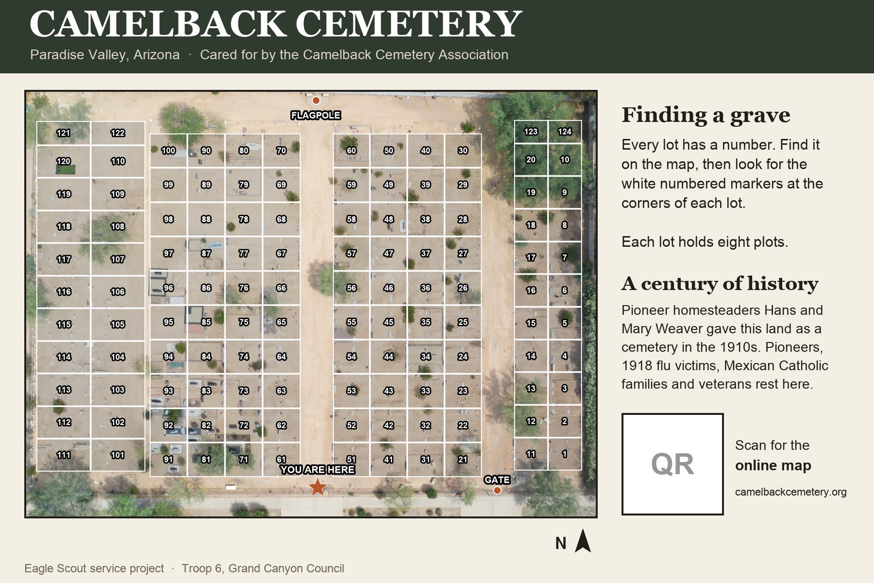
Every lot, seen from above
This is a drone photo of the cemetery with all 124 lot numbers from the Association's hand-drawn lot map laid over it, oriented the way you'll see it standing at the gate. It's a draft: on the work day we'll check every corner marker against it. The finished version becomes the pedestal map at the entrance and the online map behind its QR code.
Type a lot number, or tap any lot on the map.
Draft map. Lot positions are approximate until the Association's inventory and the marker check are done. Drone photo by Ronan.
The beneficiary
More than a century of Valley history
Camelback Cemetery sits on East McDonald Drive in Paradise Valley, across from Kiva Elementary School. It began on land donated by pioneer homesteaders Hans and Mary Weaver after their son-in-law died, just two weeks after his wedding. The family gave the land to what became the Camelback Cemetery Association, which still cares for it today.
It's the resting place of early Scottsdale and Paradise Valley pioneers, victims of the 1918 flu, Mexican Catholic families who had no other cemetery nearby, military veterans, early judges and a postmaster, and Joe "Cheyenne" Kiser, the 1923 World Champion Cowboy.
Lots
124
Plots per lot
8
Cared for by
A volunteer association
Map at the gate today
None
The project
Three things, done to last
1
A pedestal map at the entrance
A weatherproof map on an angled pedestal by the gate: an overhead drone photo of the cemetery with every lot and plot drawn on top, a "You are here" star and a short history. Built for the Arizona sun, the way national parks build their trail signs.
A QR code on the map opens the same map online.
2
Lot markers you can actually read
Each lot is marked by small 4×4 concrete blocks at its corners. We'll clean, prime and repaint them bright white with clear numbers, and pour new blocks where they're broken or missing.
We're keeping concrete on purpose: metal markers tend to get stolen.
3
A cleanup day
On the work day, a team of 20–30 Scouts will rake and tidy the paths so the grounds look their best.
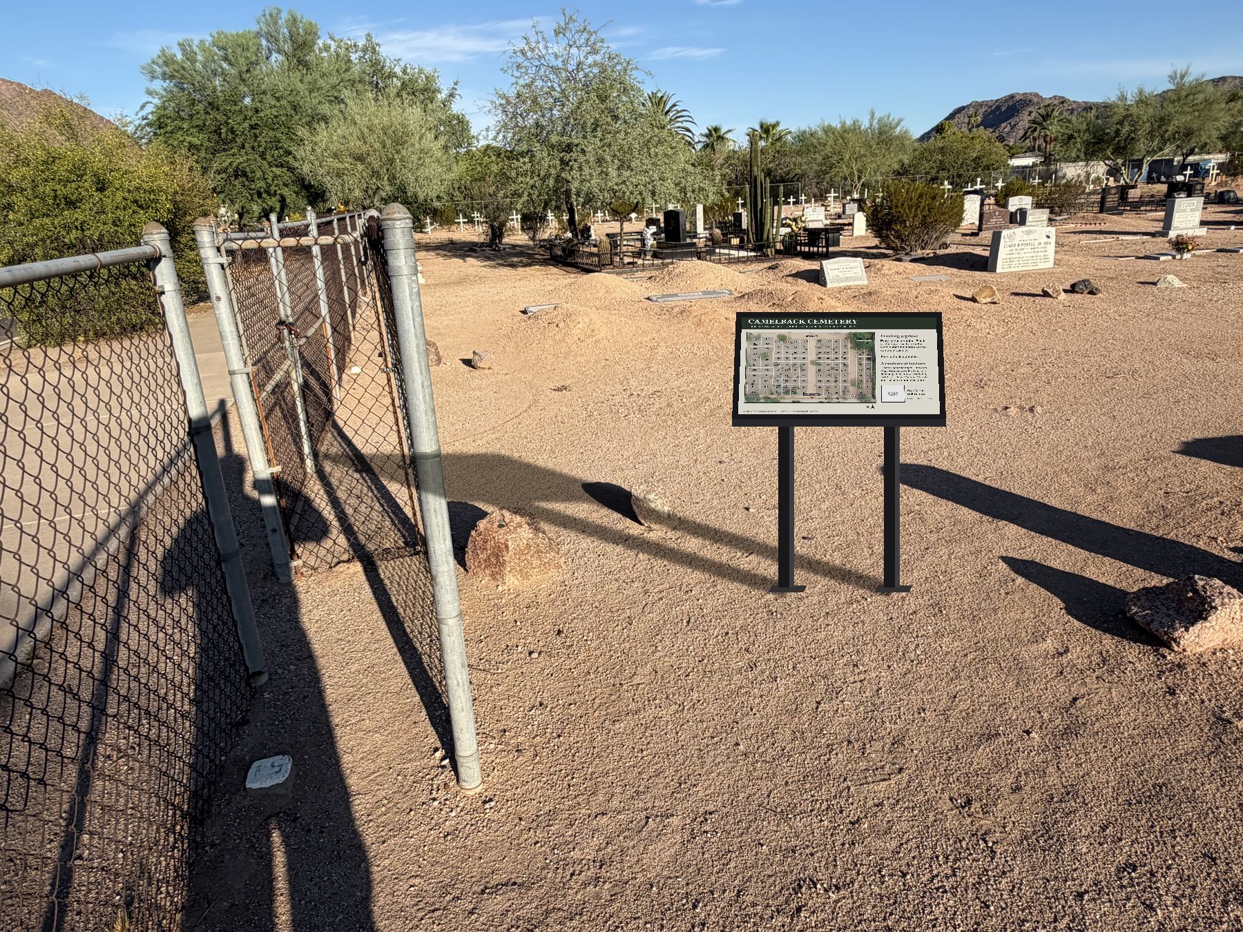
What it could look like: the pedestal map just inside the walk gate. A concept drawing on a real photo, not the final design.First draft of the 36" × 24" panel, built from the drone map.
Choosing the pedestal map
We have quotes for two kinds of 36" × 24" full-color map panel on an angled pedestal. Scout volunteers will prepare the site and install it.
Option 1
Gel-coat laminate
10-year warranty
Lower cost, very common in parks
About 8 weeks to make after the design is approved
Option 2
Porcelain enamel
25-year warranty against fading
Colors fused into glass, built for the Arizona sun
About 8–10 weeks after the design is approved
Which one we choose depends on how much we raise. Reaching the 25-year option means the map can serve families for decades.
The plan
Timeline
Plan with the Association
Met with the Camelback Cemetery Association and agreed the scope. July 2026.
Project approval
Proposal approved by Troop 6 and the Grand Canyon Council.
Fundraising
Raise the money for the pedestal map and marker materials.
Map and design
Drone photos, the lot grid and the map design, reviewed with the Association.
Work day
Scouts repaint and replace markers and clean up the grounds.
Map installed
The pedestal map goes up at the entrance, and the online map goes live.
Get involved
How you can help
Donate online
Online giving opens as soon as the project is approved. Donations go straight to the Camelback Cemetery Association.
Make checks payable to Camelback Cemetery Association, with "Ronan Simpson Eagle Project" in the memo line. Mailing details coming soon.
Pass it on
Have family at Camelback Cemetery, or know someone who does? Share this page. Local businesses can also help with materials.
About your gift
The Camelback Cemetery Association is a nonprofit cemetery company under section 501(c)(13), and gifts to it are generally tax-deductible. The Association sends a thank-you letter for every donation. Funds raised are for this project; anything left over supports the cemetery's perpetual care.